Microburbs
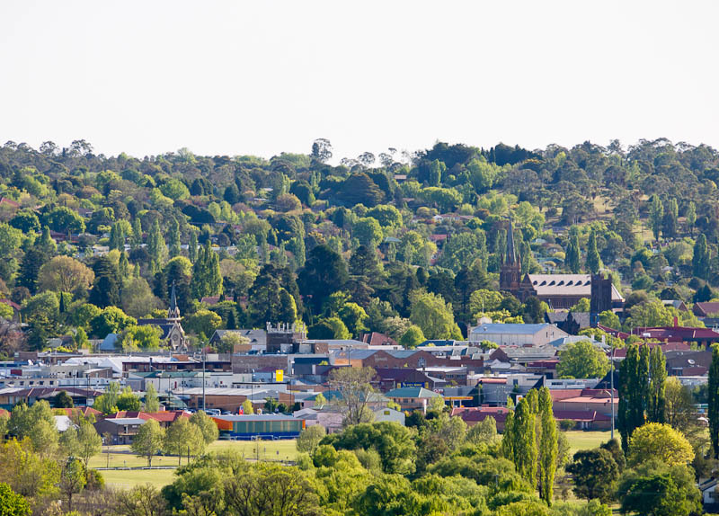
Armidale, NSW, Hills surround historical churches and town centre

Hills surround historical churches and town centre

Terry Cooke · CC BY 2.0

The quick read on

Armidale

NSW 2350 · Armidale Regional

What homes cost, how rents have moved, and a feel for the people who call it home.

Median house
$655,000

latest suburb median

Median unit
$430,000

latest suburb median

Population
23,967

ABS 2021

Postcode
2350

Armidale, New South Wales

Property market insights for Armidale

Median sale price and rental income of properties in Armidale NSW

Median price trend for houses

Based on 599 sales in the preceding 12 months

$655,000

Up 20.2% over 12 months

$800k$600k$400k20212023202420252026
1 bed
$440k
2 bed
$515k
3 bed
$592k
4 bed
$715k
5+ bed
$890k

Median rent trend for houses

Based on 538 rental listings in the preceding 12 months

$500 per week

Up 5.3% over 12 months

$500$450$400$35020212023202420252026

Market data updated October 2026.

The median house price in Armidale, NSW is currently $655,000, based on the latest 12 months of sales. Armidale has a 12-month growth rate of 20.2% for houses and 28.5% for units.

One-bedroom houses have a median sale price of $440,000, Two-bedroom houses have a median sale price of $515,000, Three-bedroom houses have a median sale price of $592,000, Four-bedroom houses have a median sale price of $715,000, Larger houses have a median sale price of $890,000 in Armidale.

If you're looking to lease, the median rent for houses in Armidale is $500 per week. The median house rent has increased 5.3% over the last 12 months.

The median price of apartments and units for sale in Armidale is $430,000, which has increased 28.5% since the same time last year. One-bedroom apartments and units have a median sale price of $142,000, Two-bedroom apartments and units have a median sale price of $345,000, Three-bedroom apartments and units have a median sale price of $550,000 in Armidale. The median rent for units and apartments in Armidale is $400 per week and has increased 23.1% over the last 12 months.

Crime and safety

Is Armidale safe?

The overall rate for Armidale is 2,715 offences per 100,000 residents — 18% below the Rest of NSW benchmark.

That is the clearest suburb-wide answer. Open the detailed profile to see how the pattern changes across offence types and different parts of Armidale.

Overall crime rate

2,715

offences per 100,000 residents

18% belowRest of NSW

ArmidaleRest of NSW: 3,298

Suburb-wide estimate from Microburbs' public crime model; it is not an address-level measure.

The people behind the postcode

Who lives in Armidale?

Armidale NSW 2350 is in New South Wales, within Rest of NSW.

23,967 people call Armidale home, with an average of 2.3 people per household and a median household income of $1,432 a week.

Public ABS 2021 Census figures. The bars compare the local share with the capital-region benchmark.

Population
23,967
Median age
36 years
Median mortgage
$1,500 / month
2021 household rent
$290 / week
Above the benchmarkBelow the benchmarkIn lineRest of NSW benchmark

Age profile

Share of residents in each age band.

Under 1517.8%In line
15–3430.8%Above
35–5421.5%Below
55–7420.9%Below
75 and over8.9%Below

Homes

Share of occupied private dwellings.

Separate houses81.7%Below
Townhouses12.3%Above
Apartments5.2%Below

Ownership

Share of homes with a stated ownership or rental status.

Owned outright33.1%Below
Paying a mortgage27.9%Below
Renting38.9%Above

Cars at home

Vehicles available to occupied households.

No car8.3%Above
One car42.1%Above
Two cars34.1%Below
Three or more15.5%Below

Getting to work

Selected ways residents worked or travelled on Census day.

Worked from home22.0%Above
Drove to work50.8%Below
Train, tram or bus0.3%In line
Walked or cycled4.1%Above

What stands out in Armidale

22.0% of workers in Armidale worked from home on Census day — noticeably more common than across Rest of NSW.

2.0% of Armidale residents were born in England.

36.1% of people in Armidale described themselves as having no religion in the 2021 Census.

A closer look at the Census

Questions people ask about Armidale

Open any question for a plain-English reading of the public 2021 Census for Armidale NSW 2350.

Is Armidale family-friendly?Age, family structure and household size describe the community families would be joining.

17.8% of Armidale's residents were children under 15 in the 2021 Census. That is almost exactly typical for Rest of NSW.

5,594 family households lived in Armidale; 36.4% were couple families and 18.4% were one-parent families.

37.4% of local families included children under 15. That is close to the Rest of NSW average.

These are suburb-wide household figures, not school or childcare ratings.

What is the age profile of Armidale?The balance between younger adults, families and older residents changes how a suburb feels day to day.

Armidale had 23,967 residents at the 2021 Census.

24.5% of residents were aged 25 to 44.

29.8% were 55 or older. That is somewhat below the Rest of NSW average.

Age shares use the suburb’s total Census population.

What kind of homes are in Armidale?The dwelling mix shows whether the suburb is mostly detached homes, townhouses or apartments.

Separate houses made up 81.7% of occupied private dwellings in Armidale.

Townhouses and other attached homes represented 12.3% of occupied private dwellings.

Flats and apartments accounted for 5.2% of occupied private dwellings.

All three shares use occupied private dwellings as the denominator.

Do people own or rent in Armidale?Tenure shows how many households own outright, have a mortgage or rent.

33.1% of households with a stated tenure owned their home outright. That is well below the Rest of NSW average.

27.9% were buying their home with a mortgage.

38.9% rented their home. That is well above the Rest of NSW average.

Tenure shares include households that stated one of these three arrangements.

How large are households in Armidale?Household-size data shows the mix behind the suburb-wide average.

The average household in Armidale had 2.3 people.

One-person households made up 32.8% of occupied homes. That is somewhat above the Rest of NSW average.

Two-person households represented 34.8%, while 19.4% had four or more usual residents.

Household size counts usual residents in occupied homes.

How do people get to work in Armidale?Census-day travel shows the balance between home, road, public transport and active travel.

22.0% of workers worked from home on Census day. That is well above the Rest of NSW average.

50.8% drove a car as their only travel method. That is well below the Rest of NSW average.

0.3% used only a train, tram or bus, while 4.1% walked or cycled.

Travel figures are a 2021 Census-day snapshot.

How many cars do households have in Armidale?Vehicle availability helps describe the routines local households can support.

8.3% of occupied households had no motor vehicle available. That is somewhat above the Rest of NSW average.

One-car households formed 42.1% of the total.

49.6% of households had two or more vehicles.

Vehicle counts refer to occupied households, not individual residents.

Who's moving to Armidale, and who stays?Address history shows how settled or recently mobile residents were at the Census date.

48.8% were at the same address five years earlier, while 51.2% reported a different address.

16.4% of residents were born outside Australia. That is somewhat above the Rest of NSW average.

Mobility figures cover residents who answered the relevant Census question.

What languages are spoken in Armidale?Language at home gives a direct view of the community’s everyday linguistic mix.

78.6% of residents used only English at home.

11.7% used a language other than English at home.

0.7% spoke Mandarin at home, 0.3% spoke Cantonese and 0.2% spoke Hindi.

Home language is separate from English proficiency.

Where were Armidale residents born?Birthplace adds another layer to the local story, separate from ancestry and language.

16.4% of Armidale's population was born outside Australia, while roughly 83.6% was born in Australia.

0.6% of residents were born in China.

1.1% were born in India, while Australian citizenship across the whole suburb stood at 80.9%.

Birthplace, citizenship and ancestry describe different parts of identity.

What ancestries shape Armidale?Ancestry responses show how residents describe family and cultural background.

English ancestry accounted for 36.1% of ancestry responses in Armidale.

Australian ancestry made up 34.9% of responses.

Chinese ancestry represented 1.7% of responses.

People may nominate more than one ancestry, so these are shares of responses.

What work do people do in Armidale?Occupation describes a person’s role; industry describes the sector employing them.

26.8% of employed residents worked in professional occupations. That is well above the Rest of NSW average.

Managers accounted for 12.5% of employed residents, while clerical and administrative workers made up 11.3%.

Health care and social assistance employed 16.2% of workers, and education and training employed 21.6%.

Occupation and industry figures describe employed residents of the suburb.

How active is the workforce in Armidale?Participation, employment pattern and unemployment describe the resident labour force.

The labour-force participation rate was 56.0%, compared with 56.4% across Rest of NSW.

30.0% of residents aged 15 and over worked full time, while 19.4% worked part time.

Unemployment was 5.7%, compared with 4.6% across Rest of NSW.

Labour-force figures come from the 2021 Census.

What does the health profile of Armidale show?Selected long-term health conditions help describe community service needs.

54.2% reported no selected long-term health condition.

10.2% reported a long-term mental health condition, including depression or anxiety.

9.4% reported asthma, 8.7% arthritis and 4.1% diabetes excluding gestational diabetes.

These are self-reported suburb-wide Census figures, not address-level health risks.

How educated is Armidale?Qualifications describe the study pathways represented among local residents.

23.8% of people in the qualifications table held a bachelor degree. That is somewhat above the Rest of NSW average.

Postgraduate degrees accounted for 15.1% of qualification responses.

Diploma-level qualifications represented 11.5%, while certificate-level qualifications represented 26.7%.

Qualification categories are reported separately and are not school ratings.

What do incomes and housing costs look like in Armidale?Census income and household payments give historical context for local living costs.

Median household income was $1,432 per week in the 2021 Census.

The median monthly mortgage repayment reported by local households was $1,500.

Occupied renting households reported a median rent of $290 per week.

These household figures are from 2021; current sale and asking-rent medians appear in the market section.

How does Armidale compare with Rest of NSW?A few clear differences place the suburb in its wider metropolitan context.

Working from home was 22.0% in Armidale, compared with 15.7% across Rest of NSW.

Outright ownership was 33.1% locally and 39.6% across Rest of NSW. That is well below the Rest of NSW average.

Renting accounted for 38.9% in Armidale, against 27.9% across Rest of NSW.

Capital-region comparisons use the same Census definitions and year.

Three useful questions

A buyer’s quick guide to Armidale

Is Armidale expensive?

The median house price is $655,000, while units and apartments sit at $430,000. Bedroom count, land and condition still create a wide range around those suburb medians.

Is Armidale good for families?

The Census counted 5,594 local families, and 17.8% of residents were under 15. That describes the community; school quality, travel times and the right fit for a particular family need separate research.

What can I get for $1.5m in Armidale?

Larger houses have a median around $890,000, the closest bedroom benchmark we hold to a $1.5m budget. Individual homes can differ substantially with block size, renovation and location.

Medians describe recorded market activity across the suburb; they are historical context, not a valuation or forecast for an individual home.

Explore the area

Streets and suburbs around Armidale

520 streets in Armidale

Street-by-street reports are not published yet. The streets below are the ones this suburb covers.

  • Abbott Rd
  • Ailsa Cr
  • Alahna Dr
  • Albion Cl
  • Aldred Ave
  • Alexander St
  • Alinnya Ln
  • Allingham St
  • Amber Cl
  • Amble Rd
  • Ampol St
  • Anchor Rd
  • Andersons Rd
  • Anton Cl
  • Apple Tree Hill Dr
  • Archibald St
  • Argunna Crescent
  • Argyle Pl
Show all 520 streets
  • Arts Rd
  • Arundel Dr
  • Arundel Dr North
  • Ash Tree Dr
  • Atherton St
  • Autumn Ln
  • A V Green St
  • Bailey Cr
  • Bain Cr
  • Baird Pl
  • Baker Pl
  • Baldwyn St
  • Balgownie Dr
  • Barclay St
  • Barney St
  • Barry St
  • Beardy St
  • Beatrice Cl
  • Beethoven Ln
  • Belinda Pl
  • Belle Ave
  • Bellevue Rd
  • Bellewood Rd
  • Ben Venue Bvd
  • Biddulph Rd
  • Bill Watson Ct
  • Bimbimbi Rd
  • Birch Cr
  • Bishop Cr
  • Blake St
  • Blanches Rd
  • Blanch Road
  • Blaxland Rd
  • Blue Wren Rd
  • Bona Vista Rd
  • Bonnar St
  • Booloominbah Dr
  • Boorolong Rd
  • Bower Pl
  • Bowman Ave
  • Box Hill Dr
  • Bracken St
  • Bradley Ct
  • Braebank Ave
  • Braund St
  • Brewery Ln
  • Brickfield Ave
  • Brogan St
  • Browning Dr
  • Brown St
  • Bruce Close
  • Bundarra Road
  • Burgess St
  • Burns Rd
  • Burrell Ct
  • Bushel St
  • Butler Ave
  • Butler Ln
  • Butler St
  • Cafferies Rd
  • Cameron Drive
  • Campbell Parade
  • Campion Pde
  • Canambe St
  • Carey Ave
  • Carlow Cl
  • Caroline Cr
  • Castledoyle Rd
  • Catherine St
  • Centennial Cl
  • Centura Cr
  • Chandler Cl
  • Chapel St
  • Chemistry Rd
  • Chestnut Ave
  • Chisholm Cl
  • Cinders Ln
  • Clara Cr
  • Claremont Rd
  • Clarks Rd
  • Claude St
  • Claverie St
  • Clover Ln
  • Cluny Rd
  • Colin Crescent
  • College Ave
  • Coluche Rd
  • Conningdale Cr
  • Cookes Rd
  • Cotswold Ave
  • Cotterell Pl
  • Crescent St
  • Crest Rd
  • Cunningham Ct
  • Curtis St
  • Cynthia Cr
  • Dala Ln
  • Dale Cr
  • Dalton Dr
  • Dangarsleigh Rd
  • Dangar St
  • David Cr
  • Dawson Ave
  • Depot Rd
  • De Silva St
  • Donald Rd
  • Donegal Tce
  • Donnelly St
  • Doris Pl
  • Dorothy Ave
  • Douglas St
  • Drew St
  • Drummond Ave
  • Dumaresq Dam Rd
  • Dumaresq Road
  • Dumaresq St
  • Dunkin St
  • Durham Rd
  • Duval St
  • Earle Page Dr
  • Eathorpe Rd
  • Edgar St
  • Edward Dr
  • Edwards Ln
  • Edward St
  • Eichorns Ln
  • Eleanor Cl
  • Elizabeth St
  • Eliza Ln
  • Elliott St
  • Elm Ave
  • Elowera Rd
  • Endeavour Dr
  • Enid St
  • Erin Ct
  • Erskine St
  • Erwin Pl
  • Eulahbar Cr
  • Evangelene Cr
  • Eva Pl
  • Faulkner St
  • Fayle Ave
  • Fender Mews
  • Finlayson Cl
  • Fiona Pl
  • Fittler Cl
  • Fittler Rd
  • Fitzgerald Ave
  • Fletcher St
  • Florence Cr
  • Forster Ave
  • Fosters Rd
  • Freeman Cr
  • Frizell Crescent
  • Gainsborough Ln
  • Galloway St
  • Gara Rd
  • Garibaldi St
  • Gentles Rd
  • Geography Rd
  • Geology Rd
  • Gf Nott Pl
  • Glass St
  • Glendower Cl
  • Glenelg Rd
  • Glen Innes Rd
  • Golden Gr
  • Golf Links Rd
  • Golgotha St
  • Gordon St
  • Grafton Rd
  • Grandview Cr
  • Grantham Pl
  • Greaves Cl
  • Grills Pl
  • Gungurru Road
  • Haga Pl
  • Hamilton Cr
  • Handel St
  • Hanlan Rd
  • Harden St
  • Hardman Cl
  • Hargrave St
  • Harrison Place
  • Harry Mcrae Dr
  • Hawke St
  • Hawthorne Cl
  • Heagney Cl
  • Heatherston Rd
  • Helen Avenue
  • Herbert Ln
  • Herbert Park Rd
  • Hickory Dr
  • Hiddens St
  • Higginbotham Ave
  • Highlands Rd
  • High St
  • Hilda Ave
  • Hillards Rd
  • Hillview Rd
  • Hinton Tce
  • Hitchcock Ln
  • Holloway St
  • Holmes Ave
  • Holmfield Dr
  • Homestead Ln
  • Honeysuckle Drive
  • Howard Pl
  • Hoys Rd
  • Hughes Pl
  • Hunt Ave
  • Illallangi Cl
  • Imbandja Ln
  • Inces Rd
  • Innisfree Ln
  • Ishbell Dr
  • Jackes St
  • James Ave
  • Jayne Cl
  • Jeffrey St
  • Jessie St
  • Jewell Ave
  • Joan Pl
  • Johnson Ave
  • Jones Ave
  • Jubilee Rd
  • Judith St
  • Kanoona Rd
  • Karina Cl
  • Kathleen Cr
  • Kearney St
  • Keena Cl
  • Kelly Ave
  • Kellys Plains Rd
  • Kellys Plains School Rd
  • Kenalmac Ave
  • Kennedy St
  • Kent Ave
  • Kentucky St
  • Kia Ora Rd
  • Kilcoy Cl
  • Kildare Ct
  • Kilkenny Cl
  • Kintyre Rd
  • Kirby Rd
  • Kirkwood St
  • Knobs Rd
  • Kruideniers Rd
  • Kuranda Ave
  • Kurrajong Cl
  • Kurrawatha Ave
  • Lambs Ave
  • Lara Ave
  • Laurence Ave
  • Letters Pl
  • Library Rd
  • Lilley Ln
  • Lingerwood Pl
  • Link Place
  • Link Rd
  • Long Swamp Rd
  • Lonsdale St
  • Lucas Ln
  • Lynches Rd
  • Lyndon Rd
  • Lynland Dr
  • Macdonald Dr
  • Madden Cl
  • Madgwick Drive
  • Manning Ct
  • Mann St
  • Markham St
  • Marree St
  • Marshall Ave
  • Marsh St
  • Martin St
  • Mason Cr
  • Maude St
  • Mayfield Ave
  • Mays Rd
  • Mcarthur Cl
  • Mcbean Ave
  • Mccannas Rd
  • Mccarthy Cr
  • Mccarthy Rd
  • Mcgrath Pl
  • Mcintosh Cr
  • Mckeon Ave
  • Mclean Ave
  • Mclennan St
  • Mcshane Ave
  • Meadow Rd
  • Melba Pl
  • Memorial Ave
  • Meredith Rd
  • Merinda Pl
  • Merino Tce
  • Micklegate Rd
  • Middle Farm Rd
  • Miller St
  • Millie St
  • Mills Rd
  • Milson Pl
  • Mitchell Pl
  • Monkton Ave
  • Monro St
  • Montes Ln
  • Montrose Cct
  • Moore Park Ln
  • Moore Park Rd
  • Moore St
  • Morris St
  • Morson Ave
  • Mossman St
  • Mott St
  • Moyes St
  • Mozeley Pl
  • Mulligans Ln
  • Murray Ave
  • Murtagh Cl
  • Myrtle Dr
  • Napier Ct
  • Nathaniel Pidgeon Dr
  • Natural Resources Rd
  • Naughten Ave
  • Nelson Pl
  • Netherton Park Ave
  • Newbury Dr
  • New England Hwy
  • Newholme Rd
  • Newling Ave
  • Newton St
  • Niagara St
  • Norman Pl
  • Norris Dr
  • Northcott St
  • Northey Dr
  • North St
  • Nyssa St
  • Oak Knob Rd
  • Oak Tree Dr
  • O'Brien Pl
  • O'Connells Rd
  • O'Connor Rd
  • O'Dell St
  • Ohio St
  • Old Gostwyck Rd
  • Old Inverell Rd
  • Oliver Ave
  • Orchard View Rd
  • Orr Dr
  • Park Rd
  • Parry Pde
  • Parsons Cl
  • Pasture St
  • Patricia Cl
  • Pearson Rd
  • Penfold Pl
  • Perrott St
  • Peter Monley Dr
  • Peterson Dr
  • Peters Pl
  • P G Love Ave
  • Phillip St
  • Phoenix Ln
  • Phyllis Cr
  • Physics Rd
  • Pine Forest Rd
  • Pinto St
  • Platform Rd
  • Pointsfield Pl
  • Ponts Rd
  • Post
  • Power Pl
  • Primrose Hill Rd
  • Proctor Street
  • Psychology Ln
  • Puddledock Rd
  • Purkiss St
  • Queen Elizabeth Dr
  • Quin Ave
  • Railway Pde
  • Range View Rd
  • Redgum Ln
  • Red Hill
  • Reginald Ave
  • Ribbon Gum Avenue
  • Richardson Ave
  • Ridley Cl
  • Ring Rd
  • Robina Cr
  • Rockvale Rd
  • Roper Ave
  • Rosecommon Ave
  • Roseneath Ln
  • Roslyn Ave
  • Ross St
  • Round Rd
  • Rowlands Rd
  • Rujala Lane
  • Rusden Ct
  • Rusden St
  • Ryan Ave
  • Salmon Ave
  • Samuelson Cr
  • Sarah Pl
  • Sattlers Rd
  • Saumarez Rd
  • Schaefer Dr
  • Scholes St
  • Schultz Ave
  • Seabrook Place
  • Seaton St
  • See Ave
  • Shambrook Ave
  • Shand Dr
  • Shannon Rd
  • Short St
  • Showground Cct
  • Simmons Rd
  • Simmons St
  • Simpson Ave
  • Smiths Rd
  • Smith St
  • Solomon Ave
  • Somerville Cl
  • Soudan St
  • Southern Cross Drive
  • Speare Ave
  • Spearmount Dr
  • Sport Une Dr
  • Springhill Lane
  • Stace St
  • St Andrews Ave
  • St Cuthberts Ave
  • Stephen St
  • Stewart Cr
  • St Johns Ave
  • Stony Ridge Rd
  • Sunrise Crescent
  • Sunset Ave
  • Sutherland Ave
  • Sylvia Cr
  • Tallawong Ln
  • Tamar Pl
  • Tancredi St
  • Tanglewood Rd
  • Tanglewood Rd South
  • Taylor St
  • The Avenue
  • The Boulevarde
  • The Short Run
  • Thompson St
  • Thomsons Rd
  • Tindal Court
  • Tingcombe St
  • Todd Cl
  • Tombs Rd
  • Translator Rd
  • Trelawney Rd
  • Trevellie Ln
  • Trevenna Rd
  • Trim St
  • Turner St
  • Tydd Bvd
  • Tysoe Cr
  • Union Rd
  • Uralla Rd
  • Ursula Rd
  • Varley Court
  • Verna Cl
  • Virginia Cl
  • Wade Ave
  • Waller Ave
  • Warrane Rd
  • Watson Ave
  • Weaver Rdge
  • Webb Pl
  • Weirs Rd
  • Wells Ln
  • Wendo St
  • Werrina Cr
  • West Ave
  • Westview Rd
  • White Ave
  • Widders Rd
  • Wigan Ave
  • Wilara
  • Williams Pl
  • Willow
  • Wilson Ave
  • Winifred Pl
  • Witherdin Ln
  • Woodlands Rd
  • Woodward St
  • Workshops Rd
  • Worrell Pl
  • Wright Pl
  • Wyvale Cl
  • Yallambee Ave
  • Yellowtail Ct
  • Yeomans Rd

Keep exploring

Is Armidale right for your search?

Use the finders to compare places and properties, or open the full report when you need the street, risk, schools and growth research.

Figures update as new market and census data arrives. This suburb overview is general information, not a valuation or financial advice.