Microburbs
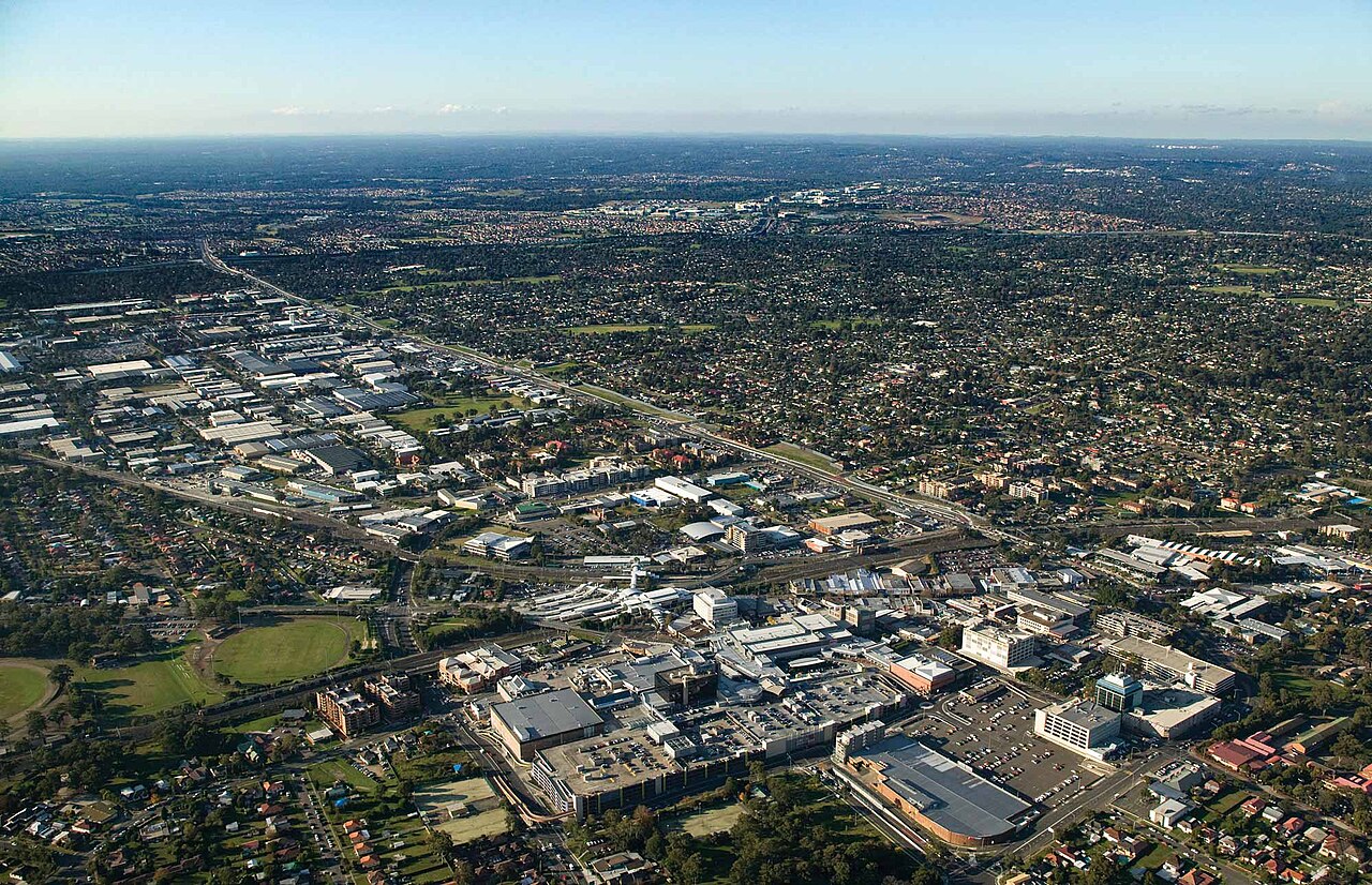
Blacktown, NSW, View showcasing urban development and greenery

View showcasing urban development and greenery

Aprilludgatefan · CC BY-SA 4.0

The quick read on

Blacktown

NSW 2148 · Blacktown

What homes cost, how rents have moved, and a feel for the people who call it home.

Median house
$1,160,000

latest suburb median

Median unit
$526,000

latest suburb median

Population
50,961

ABS 2021

Postcode
2148

Blacktown, New South Wales

Property market insights for Blacktown

Median sale price and rental income of properties in Blacktown NSW

Median price trend for houses

Based on 422 sales in the preceding 12 months

$1,160,000

Up 5.5% over 12 months

$1.2m$1m$800k20212023202420252026
2 bed
$895k
3 bed
$1.08m
4 bed
$1.25m
5+ bed
$1.36m

Median rent trend for houses

Based on 990 rental listings in the preceding 12 months

$650 per week

Up 4.0% over 12 months

$700$600$500$40020212023202420252026

Market data updated October 2026.

The median house price in Blacktown, NSW is currently $1,160,000, based on the latest 12 months of sales. Blacktown has a 12-month growth rate of 5.5% for houses and 1.3% for units.

Two-bedroom houses have a median sale price of $895,000, Three-bedroom houses have a median sale price of $1,080,000, Four-bedroom houses have a median sale price of $1,250,000, Larger houses have a median sale price of $1,360,000 in Blacktown.

If you're looking to lease, the median rent for houses in Blacktown is $650 per week. The median house rent has increased 4.0% over the last 12 months.

The median price of apartments and units for sale in Blacktown is $526,000, which has increased 1.3% since the same time last year. One-bedroom apartments and units have a median sale price of $413,000, Two-bedroom apartments and units have a median sale price of $468,000, Three-bedroom apartments and units have a median sale price of $800,000, Four-bedroom apartments and units have a median sale price of $955,000 in Blacktown. The median rent for units and apartments in Blacktown is $575 per week and has remained unchanged over the last 12 months.

Crime and safety

Is Blacktown safe?

The overall rate for Blacktown is 8,119 offences per 100,000 residents — 136% above the Greater Sydney benchmark.

That is the clearest suburb-wide answer. Open the detailed profile to see how the pattern changes across offence types and different parts of Blacktown.

Overall crime rate

8,119

offences per 100,000 residents

136% aboveGreater Sydney

BlacktownGreater Sydney: 3,437

Suburb-wide estimate from Microburbs' public crime model; it is not an address-level measure.

The people behind the postcode

Who lives in Blacktown?

Blacktown NSW 2148 is in New South Wales, within Greater Sydney.

50,961 people call Blacktown home, with an average of 2.9 people per household and a median household income of $1,774 a week.

Public ABS 2021 Census figures. The bars compare the local share with the capital-region benchmark.

Population
50,961
Median age
34 years
Median mortgage
$2,094 / month
2021 household rent
$400 / week
Above the benchmarkBelow the benchmarkIn lineGreater Sydney benchmark

Age profile

Share of residents in each age band.

Under 1519.3%Above
15–3431.4%Above
35–5426.9%Below
55–7416.5%Below
75 and over5.9%Below

Homes

Share of occupied private dwellings.

Separate houses65.4%Above
Townhouses18.6%Above
Apartments15.8%Below

Ownership

Share of homes with a stated ownership or rental status.

Owned outright22.4%Below
Paying a mortgage32.8%Below
Renting44.8%Above

Cars at home

Vehicles available to occupied households.

No car9.9%Below
One car42.3%Above
Two cars32.5%In line
Three or more15.3%Below

Getting to work

Selected ways residents worked or travelled on Census day.

Worked from home25.9%Below
Drove to work42.7%Above
Train, tram or bus4.9%Above
Walked or cycled1.7%Below

What stands out in Blacktown

25.9% of workers in Blacktown worked from home on Census day — less common than across Greater Sydney.

16.6% of Blacktown residents were born in India, about twice the rate across Greater Sydney.

16.8% of people in Blacktown described themselves as having no religion in the 2021 Census.

A closer look at the Census

Questions people ask about Blacktown

Open any question for a plain-English reading of the public 2021 Census for Blacktown NSW 2148.

Is Blacktown family-friendly?Age, family structure and household size describe the community families would be joining.

19.3% of Blacktown's residents were children under 15 in the 2021 Census. That is close to the Greater Sydney average.

12,986 family households lived in Blacktown; 50.7% were couple families and 16.9% were one-parent families.

42.8% of local families included children under 15. That is somewhat above the Greater Sydney average.

These are suburb-wide household figures, not school or childcare ratings.

What is the age profile of Blacktown?The balance between younger adults, families and older residents changes how a suburb feels day to day.

Blacktown had 50,961 residents at the 2021 Census.

34.2% of residents were aged 25 to 44.

22.4% were 55 or older. That is somewhat below the Greater Sydney average.

Age shares use the suburb’s total Census population.

What kind of homes are in Blacktown?The dwelling mix shows whether the suburb is mostly detached homes, townhouses or apartments.

Separate houses made up 65.4% of occupied private dwellings in Blacktown.

Townhouses and other attached homes represented 18.6% of occupied private dwellings.

Flats and apartments accounted for 15.8% of occupied private dwellings.

All three shares use occupied private dwellings as the denominator.

Do people own or rent in Blacktown?Tenure shows how many households own outright, have a mortgage or rent.

22.4% of households with a stated tenure owned their home outright. That is well below the Greater Sydney average.

32.8% were buying their home with a mortgage.

44.8% rented their home. That is well above the Greater Sydney average.

Tenure shares include households that stated one of these three arrangements.

How large are households in Blacktown?Household-size data shows the mix behind the suburb-wide average.

The average household in Blacktown had 2.9 people.

One-person households made up 20.5% of occupied homes. That is somewhat below the Greater Sydney average.

Two-person households represented 27.0%, while 32.3% had four or more usual residents.

Household size counts usual residents in occupied homes.

How do people get to work in Blacktown?Census-day travel shows the balance between home, road, public transport and active travel.

25.9% of workers worked from home on Census day. That is well below the Greater Sydney average.

42.7% drove a car as their only travel method. That is well above the Greater Sydney average.

4.9% used only a train, tram or bus, while 1.7% walked or cycled.

Travel figures are a 2021 Census-day snapshot.

How many cars do households have in Blacktown?Vehicle availability helps describe the routines local households can support.

9.9% of occupied households had no motor vehicle available. That is close to the Greater Sydney average.

One-car households formed 42.3% of the total.

47.8% of households had two or more vehicles.

Vehicle counts refer to occupied households, not individual residents.

Who's moving to Blacktown, and who stays?Address history shows how settled or recently mobile residents were at the Census date.

53.7% were at the same address five years earlier, while 46.3% reported a different address.

50.1% of residents were born outside Australia. That is well above the Greater Sydney average.

Mobility figures cover residents who answered the relevant Census question.

What languages are spoken in Blacktown?Language at home gives a direct view of the community’s everyday linguistic mix.

39.3% of residents used only English at home.

53.7% used a language other than English at home.

2.5% spoke Mandarin at home, 1.4% spoke Cantonese and 4.4% spoke Hindi.

Home language is separate from English proficiency.

Where were Blacktown residents born?Birthplace adds another layer to the local story, separate from ancestry and language.

50.1% of Blacktown's population was born outside Australia, while roughly 49.9% was born in Australia.

2.4% of residents were born in China.

16.6% were born in India, while Australian citizenship across the whole suburb stood at 72.1%.

Birthplace, citizenship and ancestry describe different parts of identity.

What ancestries shape Blacktown?Ancestry responses show how residents describe family and cultural background.

English ancestry accounted for 14.6% of ancestry responses in Blacktown.

Australian ancestry made up 15.7% of responses.

Chinese ancestry represented 5.3% of responses.

People may nominate more than one ancestry, so these are shares of responses.

What work do people do in Blacktown?Occupation describes a person’s role; industry describes the sector employing them.

19.9% of employed residents worked in professional occupations. That is well below the Greater Sydney average.

Managers accounted for 8.0% of employed residents, while clerical and administrative workers made up 14.4%.

Health care and social assistance employed 15.3% of workers, and education and training employed 5.9%.

Occupation and industry figures describe employed residents of the suburb.

How active is the workforce in Blacktown?Participation, employment pattern and unemployment describe the resident labour force.

The labour-force participation rate was 57.2%, compared with 60.0% across Greater Sydney.

29.6% of residents aged 15 and over worked full time, while 15.8% worked part time.

Unemployment was 7.1%, compared with 5.1% across Greater Sydney.

Labour-force figures come from the 2021 Census.

What does the health profile of Blacktown show?Selected long-term health conditions help describe community service needs.

65.6% reported no selected long-term health condition.

6.0% reported a long-term mental health condition, including depression or anxiety.

6.2% reported asthma, 6.2% arthritis and 6.2% diabetes excluding gestational diabetes.

These are self-reported suburb-wide Census figures, not address-level health risks.

How educated is Blacktown?Qualifications describe the study pathways represented among local residents.

29.1% of people in the qualifications table held a bachelor degree. That is somewhat below the Greater Sydney average.

Postgraduate degrees accounted for 13.4% of qualification responses.

Diploma-level qualifications represented 15.3%, while certificate-level qualifications represented 23.7%.

Qualification categories are reported separately and are not school ratings.

What do incomes and housing costs look like in Blacktown?Census income and household payments give historical context for local living costs.

Median household income was $1,774 per week in the 2021 Census.

The median monthly mortgage repayment reported by local households was $2,094.

Occupied renting households reported a median rent of $400 per week.

These household figures are from 2021; current sale and asking-rent medians appear in the market section.

How does Blacktown compare with Greater Sydney?A few clear differences place the suburb in its wider metropolitan context.

Working from home was 25.9% in Blacktown, compared with 38.9% across Greater Sydney.

Outright ownership was 22.4% locally and 28.6% across Greater Sydney. That is well below the Greater Sydney average.

Renting accounted for 44.8% in Blacktown, against 37.1% across Greater Sydney.

Capital-region comparisons use the same Census definitions and year.

Three useful questions

A buyer’s quick guide to Blacktown

Is Blacktown expensive?

The median house price is $1,160,000, while units and apartments sit at $526,000. Bedroom count, land and condition still create a wide range around those suburb medians.

Is Blacktown good for families?

The Census counted 12,986 local families, and 19.3% of residents were under 15. That describes the community; school quality, travel times and the right fit for a particular family need separate research.

What can I get for $1.5m in Blacktown?

Larger houses have a median around $1,360,000, the closest bedroom benchmark we hold to a $1.5m budget. Individual homes can differ substantially with block size, renovation and location.

Medians describe recorded market activity across the suburb; they are historical context, not a valuation or forecast for an individual home.

Explore the area

Streets and suburbs around Blacktown

429 streets in Blacktown

Street-by-street reports are not published yet. The streets below are the ones this suburb covers.

  • Abelia
  • Adella Ave
  • Ailsa Ave
  • Ajax Pl
  • Alam St
  • Alexander Pde
  • Aliberti Dr
  • Allawah St
  • Allay St
  • Allen Rd
  • Alpha St
  • Altona Pl
  • Amiens Ln
  • Andre Pl
  • Anne St
  • Anthony St
  • Apex St
  • Archer St
Show all 429 streets
  • Arthur Ave
  • Ashgrove Cr
  • Ash St
  • Ashwell Rd
  • Athlone St
  • Augusta St
  • Ayrton St
  • Azalea St
  • Bailey Pl
  • Baker St
  • Balbeek Ave
  • Balin Pl
  • Balmoral St
  • Baronta St
  • Barwon Glde
  • Beaufort Rd
  • Becharry Rd
  • Bedford Rd
  • Bedivere St
  • Bellevista St
  • Bellevue St
  • Benaud St
  • Berg St
  • Bessemer St
  • Betty St
  • Bimbil St
  • Birdie Cct
  • Birnam Ave
  • Blacktown Rd
  • Blattman Cl
  • Blue Hills Cr
  • Boiler Cl
  • Booreea St
  • Bowral Rd
  • Boyd St
  • Boys Ave
  • Braddon St
  • Brickfield Pl
  • Bridge View St
  • Bristol Cct
  • Bruce St
  • Buckley Ave
  • Bungarribee Rd
  • Burdett Cr
  • Burke St
  • Burnie St
  • Burrell Pde
  • Butterfield St
  • Caddy St
  • Caldwell Pl
  • Cambridge St
  • Campbell St
  • Cansdale St
  • Cardiff St
  • Carinya St
  • Carnegie Pl
  • Castle St
  • Catalpa
  • Cavendish Ave
  • Cedar Pl
  • Chansa Pl
  • Charles St
  • Chester St
  • Chicago Ave
  • Chippers Glde
  • Clarence St
  • Clare St
  • Clayton St
  • Clifton St
  • Cobb Ln
  • Colo Ln
  • Coolabah Pl
  • Cooper St
  • Coralgum Pl
  • Cornell St
  • Craiglea St
  • Craig St
  • Cumberland St
  • Cunningham Cr
  • Cut Glde
  • Cypress Ln
  • Dagmar Cr
  • Dan Ave
  • Daniela Pl
  • Daphne Pl
  • David Ln
  • Dawn Dr
  • De Castella Dr
  • Dell St
  • Delta Pl
  • Deodar
  • Derby St
  • Derwent Pde
  • Devitt St
  • Dina Beth Ave
  • Dinton St
  • Doonside Cr
  • Dora St
  • Dorset St
  • Douglas Rd
  • Drake Pl
  • Driving Glde
  • Duckmallois Ave
  • Dudley Ave
  • Dunn
  • Dunstable Rd
  • Eastlakes Glde
  • Eggleton St
  • Elanora Ave
  • Ellerston Glde
  • Elouera Ln
  • Eltham St
  • Erith St
  • Essence Glde
  • Essex St
  • Eta St
  • Fairwater Bvd
  • Farmingdale Dr
  • Felicia Pl
  • Fern Pl
  • Fife St
  • Fifth Ave
  • Filey St
  • Finlay St
  • First Ave
  • Flame Pl
  • Flushcombe Rd
  • Flyer Glde
  • Forge St
  • Foss St
  • Fourth Ave
  • Frederick St
  • Friend Pl
  • Fringe Glade
  • Fullam Rd
  • Gardenset Gr
  • Garden St
  • Gareth St
  • Gate Rd
  • George St
  • Gibson Pl
  • Girra Rd
  • Glamorgan St
  • Golfer Walkway
  • Gordon St
  • Gould
  • Grafton St
  • Grant St
  • Greenbank Dr
  • Green St
  • Greenwood Gr
  • Gribble Pl
  • Griffiths St
  • Hackett
  • Hadrian Ave
  • Harold St
  • Havenwood Pl
  • Hawkins St
  • Hayley Gr
  • Heapey St
  • Heart Pl
  • Heliotrope Cr
  • Hereward Hwy
  • Herrick St
  • Highlands Cr
  • Highpoint Dr
  • Highview St
  • Hillside Rd
  • Hilltop Ave
  • Holbeche Rd
  • Huegill
  • Hunter St
  • Huntingdale Glde
  • Huntley Dr
  • Ida Pl
  • Indigo
  • Iona St
  • Irelands Rd
  • Iris Pl
  • Ironbark Cr
  • Ironwood Cr
  • Jabiru Pl
  • Jane St
  • Jem Pl
  • Jennifer Ave
  • Johnboy Pl
  • John St
  • Jones St
  • Joseph St
  • Julie St
  • June St
  • Juniper
  • Kastelan St
  • Kauri St
  • Kay St
  • Keld Pl
  • Kelso Ln
  • Kempsey St
  • Kenji Pl
  • Kent St
  • Kerry Rd
  • Keyworth Dr
  • Kieren Dr
  • Kildare Rd
  • Killarney Ave
  • Kingsford St
  • Kirkman Rd
  • Klim
  • Kurrajong Cr
  • Lacey Pl
  • Laker St
  • Lancaster St
  • Lancelot St
  • Lander Ave
  • Lavender Pl
  • Leat Pl
  • Lees Cr
  • Leicester Sq
  • Leonard St
  • Leslie St
  • Lismore St
  • Lloyd St
  • Lock St
  • London St
  • Love St
  • Lucas Rd
  • Luton Rd
  • Lynwood Ave
  • Lyton St
  • Main St
  • Mala Cr
  • Malcolm St
  • Maloney St
  • Malouf Pl
  • Mantaka St
  • Marana St
  • Marcel Cr
  • Maree Pl
  • Maria Pl
  • Mariko Pl
  • Marion St
  • Mary St
  • Matthew Cr
  • Maud St
  • Maureen Pl
  • Maxwell St
  • Mcclean St
  • Mcculloch Rd
  • Meath Pl
  • Meela St
  • Merlin St
  • Meroo St
  • Monash Rd
  • Monroe St
  • Moren St
  • Moroney Cl
  • Mort St
  • Muirfield Glde
  • Mulgi St
  • Muringo
  • Murray Pl
  • Muru Way
  • Nash Pl
  • Nerada St
  • Newhaven Ave
  • Newman St
  • Newton Rd
  • Nicholas St
  • Norfolk St
  • Northcott Rd
  • Northumberland St
  • Oatley Cl
  • Oft Pl
  • Olga St
  • Ondieki Ct
  • Orallo Ave
  • Oregon St
  • Orwell St
  • Outlook St
  • Oxford St
  • Palmer Pl
  • Pank Pde
  • Panorama Pde
  • Par Glde
  • Parkland St
  • Patricia St
  • Patrick St
  • Paul St
  • Pavonia
  • Pelleas St
  • Pembroke St
  • Pendant Ave
  • Peter Street
  • Philip St
  • Picardy St
  • Picken Ln
  • Pollack St
  • Prince St
  • Privet
  • Prospect St
  • Putters Cct
  • Quail Rd
  • Queensway
  • Railway Pde
  • Range Glde
  • Raymond Street
  • Redwood St
  • Reservoir Rd
  • Richmond Road
  • Ridley Pl
  • Roa Pl
  • Robina St
  • Robyn St
  • Roger Pl
  • Roma Ave
  • Ronald St
  • Rosemary Pl
  • Ross Street
  • Royena
  • Russell St
  • Rutherford St
  • Rutland St
  • Sackville St
  • Sarsfield St
  • Savery Crescent
  • Saxby
  • Second Ave
  • Selby Pl
  • Shelley Cr
  • Shirley St
  • Siebel St
  • Sinclair Ave
  • Sixteenth Glde
  • Sparkle Ave
  • Spoonbill Ave
  • Springfield Ave
  • Spruce St
  • Stableford St
  • St Andrews Crescent
  • Stanley St
  • Starr Pl
  • Steel St
  • Stella Place
  • Stephen St
  • Sterlini Cl
  • Stewart Ave
  • St Martins Cr
  • St Pauls
  • Suffolk St
  • Sullivan St
  • Sunnyholt Rd
  • Sunville Ct
  • Surrey St
  • Sutton St
  • Swinson Road
  • Sydney St
  • Sylvia St
  • Tallawong Ave
  • Tara Road
  • Taronga St
  • Teagan Pl
  • Teal Pl
  • Tee Glde
  • Templar St
  • Tenby St
  • Theresa St
  • Third Ave
  • Thistle
  • Thorpe
  • Timmins
  • Tudor Ave
  • Tulloch St
  • Turner St
  • Turvey Rd
  • Twilight Cr
  • Tyrone Pl
  • Valda St
  • Valentine St
  • Valetta Ct
  • Van Bentum Pl
  • Vardys Rd
  • Vella Crescent
  • Vezey Pl
  • Vincent St
  • Virginia St
  • Wallaby Cl
  • Wallace St
  • Wall Park Ave
  • Walters Rd
  • Warrick Ln
  • Warrigal St
  • Wattle St
  • Watts Gr
  • Waugh Cr
  • Wedge Glde
  • Western Cr
  • Westfield Pl
  • Westlake Glde
  • West St
  • Wilga St
  • William St
  • Winifred Cr
  • Winter Pl
  • Wirilda
  • Wirruna St
  • Wistaria Pl
  • Woodside Ave
  • Wright St
  • Wye St
  • Yale Pl
  • Zinnia

Keep exploring

Is Blacktown right for your search?

Use the finders to compare places and properties, or open the full report when you need the street, risk, schools and growth research.

Figures update as new market and census data arrives. This suburb overview is general information, not a valuation or financial advice.