Microburbs
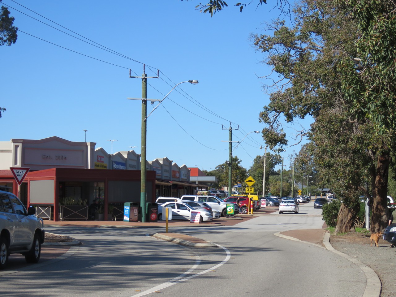
Byford, WA, Shops and parking on a curved street

Shops and parking on a curved street

Calistemon · CC BY-SA 4.0

The quick read on

Byford

WA 6122 · Serpentine-Jarrahdale

What homes cost, how rents have moved, and a feel for the people who call it home.

Median house
$850,000

latest suburb median

Population
18,878

ABS 2021

Postcode
6122

Byford, Western Australia

Property market insights for Byford

Median sale price and rental income of properties in Byford WA

Median price trend for houses

Based on 416 sales in the preceding 12 months

$850,000

Up 20.6% over 12 months

$1m$750k$500k20212023202420252026
2 bed
$655k
3 bed
$751k
4 bed
$882k
5+ bed
$1m

Median rent trend for houses

Based on 275 rental listings in the preceding 12 months

$675 per week

Up 8.0% over 12 months

$700$600$500$40020212023202420252026

Market data updated October 2026.

The median house price in Byford, WA is currently $850,000, based on the latest 12 months of sales. Byford has a 12-month growth rate of 20.6% for houses.

Two-bedroom houses have a median sale price of $655,000, Three-bedroom houses have a median sale price of $751,000, Four-bedroom houses have a median sale price of $882,000, Larger houses have a median sale price of $1,000,000 in Byford.

If you're looking to lease, the median rent for houses in Byford is $675 per week. The median house rent has increased 8.0% over the last 12 months.

Three-bedroom apartments and units have a median sale price of $770,000 in Byford.

Crime and safety

Is Byford safe?

The overall rate for Byford is 6,164 offences per 100,000 residents — 21% below the Greater Perth benchmark.

That is the clearest suburb-wide answer. Open the detailed profile to see how the pattern changes across offence types and different parts of Byford.

Overall crime rate

6,164

offences per 100,000 residents

21% belowGreater Perth

ByfordGreater Perth: 7,809

Suburb-wide estimate from Microburbs' public crime model; it is not an address-level measure.

The people behind the postcode

Who lives in Byford?

Byford WA 6122 is in Western Australia, within Greater Perth.

18,878 people call Byford home, with an average of 3 people per household and a median household income of $2,059 a week.

Public ABS 2021 Census figures. The bars compare the local share with the capital-region benchmark.

Population
18,878
Median age
31 years
Median mortgage
$1,898 / month
2021 household rent
$380 / week
Above the benchmarkBelow the benchmarkIn lineGreater Perth benchmark

Age profile

Share of residents in each age band.

Under 1528.9%Above
15–3429.2%Above
35–5427.0%In line
55–7412.2%Below
75 and over2.6%Below

Homes

Share of occupied private dwellings.

Separate houses98.7%Above
Townhouses1.1%Below
Apartments0.1%Below

Ownership

Share of homes with a stated ownership or rental status.

Owned outright14.2%Below
Paying a mortgage70.1%Above
Renting15.6%Below

Cars at home

Vehicles available to occupied households.

No car1.4%Below
One car26.4%Below
Two cars46.2%Above
Three or more26.1%Above

Getting to work

Selected ways residents worked or travelled on Census day.

Worked from home5.0%Below
Drove to work68.1%Above
Train, tram or bus2.4%Below
Walked or cycled1.1%Below

What stands out in Byford

5.0% of workers in Byford worked from home on Census day.

7.2% of Byford residents were born in England.

50.7% of people in Byford described themselves as having no religion in the 2021 Census.

A closer look at the Census

Questions people ask about Byford

Open any question for a plain-English reading of the public 2021 Census for Byford WA 6122.

Is Byford family-friendly?Age, family structure and household size describe the community families would be joining.

28.9% of Byford's residents were children under 15 in the 2021 Census. That is well above the Greater Perth average.

5,098 family households lived in Byford; 55.1% were couple families and 15.8% were one-parent families.

55.7% of local families included children under 15. That is well above the Greater Perth average.

These are suburb-wide household figures, not school or childcare ratings.

What is the age profile of Byford?The balance between younger adults, families and older residents changes how a suburb feels day to day.

Byford had 18,878 residents at the 2021 Census.

35.0% of residents were aged 25 to 44.

14.9% were 55 or older. That is about half the Greater Perth rate.

Age shares use the suburb’s total Census population.

What kind of homes are in Byford?The dwelling mix shows whether the suburb is mostly detached homes, townhouses or apartments.

Separate houses made up 98.7% of occupied private dwellings in Byford.

Townhouses and other attached homes represented 1.1% of occupied private dwellings.

Flats and apartments accounted for 0.1% of occupied private dwellings.

All three shares use occupied private dwellings as the denominator.

Do people own or rent in Byford?Tenure shows how many households own outright, have a mortgage or rent.

14.2% of households with a stated tenure owned their home outright. That is about half the Greater Perth rate.

70.1% were buying their home with a mortgage.

15.6% rented their home. That is well below the Greater Perth average.

Tenure shares include households that stated one of these three arrangements.

How large are households in Byford?Household-size data shows the mix behind the suburb-wide average.

The average household in Byford had 3.0 people.

One-person households made up 15.1% of occupied homes. That is well below the Greater Perth average.

Two-person households represented 28.1%, while 38.0% had four or more usual residents.

Household size counts usual residents in occupied homes.

How do people get to work in Byford?Census-day travel shows the balance between home, road, public transport and active travel.

5.0% of workers worked from home on Census day. That is somewhat below the Greater Perth average.

68.1% drove a car as their only travel method. That is well above the Greater Perth average.

2.4% used only a train, tram or bus, while 1.1% walked or cycled.

Travel figures are a 2021 Census-day snapshot.

How many cars do households have in Byford?Vehicle availability helps describe the routines local households can support.

1.4% of occupied households had no motor vehicle available. That is about half the Greater Perth rate.

One-car households formed 26.4% of the total.

72.3% of households had two or more vehicles.

Vehicle counts refer to occupied households, not individual residents.

Who's moving to Byford, and who stays?Address history shows how settled or recently mobile residents were at the Census date.

57.7% were at the same address five years earlier, while 42.3% reported a different address.

27.7% of residents were born outside Australia. That is well below the Greater Perth average.

Mobility figures cover residents who answered the relevant Census question.

What languages are spoken in Byford?Language at home gives a direct view of the community’s everyday linguistic mix.

80.9% of residents used only English at home.

14.9% used a language other than English at home.

0.5% spoke Mandarin at home, 0.2% spoke Cantonese and 0.4% spoke Hindi.

Home language is separate from English proficiency.

Where were Byford residents born?Birthplace adds another layer to the local story, separate from ancestry and language.

27.7% of Byford's population was born outside Australia, while roughly 72.3% was born in Australia.

0.2% of residents were born in China.

3.5% were born in India, while Australian citizenship across the whole suburb stood at 85.4%.

Birthplace, citizenship and ancestry describe different parts of identity.

What ancestries shape Byford?Ancestry responses show how residents describe family and cultural background.

English ancestry accounted for 42.7% of ancestry responses in Byford.

Australian ancestry made up 36.9% of responses.

Chinese ancestry represented 1.2% of responses.

People may nominate more than one ancestry, so these are shares of responses.

What work do people do in Byford?Occupation describes a person’s role; industry describes the sector employing them.

12.4% of employed residents worked in professional occupations. That is about half the Greater Perth rate.

Managers accounted for 8.7% of employed residents, while clerical and administrative workers made up 13.5%.

Health care and social assistance employed 13.1% of workers, and education and training employed 6.8%.

Occupation and industry figures describe employed residents of the suburb.

How active is the workforce in Byford?Participation, employment pattern and unemployment describe the resident labour force.

The labour-force participation rate was 72.7%, compared with 65.2% across Greater Perth.

44.0% of residents aged 15 and over worked full time, while 20.9% worked part time.

Unemployment was 4.3%, compared with 5.3% across Greater Perth.

Labour-force figures come from the 2021 Census.

What does the health profile of Byford show?Selected long-term health conditions help describe community service needs.

65.4% reported no selected long-term health condition.

8.8% reported a long-term mental health condition, including depression or anxiety.

8.4% reported asthma, 5.2% arthritis and 3.8% diabetes excluding gestational diabetes.

These are self-reported suburb-wide Census figures, not address-level health risks.

How educated is Byford?Qualifications describe the study pathways represented among local residents.

15.5% of people in the qualifications table held a bachelor degree. That is well below the Greater Perth average.

Postgraduate degrees accounted for 3.6% of qualification responses.

Diploma-level qualifications represented 17.0%, while certificate-level qualifications represented 50.1%.

Qualification categories are reported separately and are not school ratings.

What do incomes and housing costs look like in Byford?Census income and household payments give historical context for local living costs.

Median household income was $2,059 per week in the 2021 Census.

The median monthly mortgage repayment reported by local households was $1,898.

Occupied renting households reported a median rent of $380 per week.

These household figures are from 2021; current sale and asking-rent medians appear in the market section.

How does Byford compare with Greater Perth?A few clear differences place the suburb in its wider metropolitan context.

Working from home was 5.0% in Byford, compared with 7.6% across Greater Perth.

Outright ownership was 14.2% locally and 29.3% across Greater Perth. That is about half the Greater Perth rate.

Renting accounted for 15.6% in Byford, against 27.5% across Greater Perth.

Capital-region comparisons use the same Census definitions and year.

Three useful questions

A buyer’s quick guide to Byford

Is Byford expensive?

The median house price is $850,000. Bedroom count, land and condition still create a wide range around those suburb medians.

Is Byford good for families?

The Census counted 5,098 local families, and 28.9% of residents were under 15. That describes the community; school quality, travel times and the right fit for a particular family need separate research.

What can I get for $1.5m in Byford?

Larger houses have a median around $1,000,000, the closest bedroom benchmark we hold to a $1.5m budget. Individual homes can differ substantially with block size, renovation and location.

Medians describe recorded market activity across the suburb; they are historical context, not a valuation or forecast for an individual home.

Explore the area

Streets and suburbs around Byford

438 streets in Byford

Street-by-street reports are not published yet. The streets below are the ones this suburb covers.

  • Abernethy Rd
  • Adiantum Ave
  • Agate
  • Alata Gr
  • Albion Rd
  • Albizia Gr
  • Aldred
  • Alexander Rd
  • Allanson Dr
  • Amy St
  • Annato Ent
  • Anzac Cr
  • Ararat Rd
  • Araucaria Bvd
  • Archer St
  • Armadan Court
  • Aspinall Rd
  • Astartea Pl
Show all 438 streets
  • Aventurine
  • Ayrshire Vsta
  • Balin
  • Ballagar Rd
  • Ballawarra Ave
  • Bandin
  • Banjine Way
  • Banker St
  • Barber Ln
  • Barjadda St
  • Barnard Gr
  • Barraberry
  • Bateman St
  • Bathurst St
  • Battams
  • Batty Rd
  • Baystone St
  • Beaufortia Crescent
  • Beenyup Rd
  • Benalla Cr
  • Bendigo Boulevard
  • Bevis Ct
  • Bingham
  • Binns Ln
  • Binshaw Ave
  • Bitalli
  • Blackberry
  • Blancoa App
  • Blueberry Loop
  • Blytheswood Ave
  • Blytheswood Rd
  • Bofors Ln
  • Bookleaf Street
  • Boorn
  • Bosun
  • Bowyer Pl
  • Bradley Cl
  • Bradshaw Rd
  • Braford
  • Braidwood Rd
  • Brangus Vsta
  • Bren Cl
  • Brick Ln
  • Briggs Road
  • Brixton Cl
  • Bromus
  • Brown St
  • Bunney Pl
  • Bunya
  • Burgess Dr
  • Burrell St
  • Bushman Glde
  • Byford Dr
  • Calibre Vsta
  • Calneggia Dr
  • Camembert St
  • Caraway Ave
  • Carbine
  • Cardup Siding Rd
  • Carinata Cr
  • Carnelian
  • Carroll Ln
  • Caspian Chase
  • Castello Cr
  • Casterton Rd
  • Catherine St
  • Catkin Way
  • Cattach
  • Cauthern Gr
  • Charles St
  • Chicory
  • Chidlow
  • Choules St
  • Chrysomou St
  • Cinnabar
  • Clara St
  • Clematis St
  • Clifton St
  • Clondyke Dr
  • Clough Link
  • Coastal Street
  • Colby
  • Colesbrook Dr
  • Coles St
  • Connemarra Street
  • Cooperage St
  • Copper Rd
  • Corbel Ln
  • Cordite Cct
  • Corymbia Bvd
  • Coulterhand
  • Covenant Ln
  • Cowara
  • Cranbourne
  • Crillin
  • Cristonia Tce
  • Crossing
  • Culham Vsta
  • Curacoa
  • Dagostino Rd
  • Daimpre
  • Dalgleish Gr
  • Dalley St
  • Daran
  • Darby
  • Dearden Rd
  • Delianuova St
  • Diamantina Bvd
  • Doley Rd
  • Dougall St
  • Dowak Ln
  • Dulcify Lane
  • Dundatha Dr
  • Dunlop
  • Durling Road
  • D'Vitale
  • Edward Cr
  • Efficient
  • Elston Ct
  • Encounter Rd
  • Enfield
  • Ethereal Rd
  • Eurythmic Rd
  • Evans
  • Extensa Crescent
  • Farncomb Street
  • Farnell Rd
  • Fawcett Rd
  • Fitzgerald Dr
  • Flux Way
  • Foreman St
  • Foulkes
  • Freestall
  • Fuchsia Street
  • Gaddara
  • Gadd Ave
  • Gaffin Rd
  • Galena
  • Gallant
  • Gallipoli Ave
  • Gallon
  • George St
  • Gingerale
  • Glenloth Rd
  • Godfrey
  • Golding Ln
  • Goodenia Vsta
  • Gordin
  • Gouda Vsta
  • Goulburn Pwy
  • Graceful St
  • Grana Vsta
  • Granfell
  • Granite App
  • Gratiola Rd
  • Guava
  • Guernsey Cr
  • Gunsynd Lane
  • Guraga
  • Hackney Loop
  • Haflinger
  • Halfpenny Ave
  • Halliday Rd
  • Hanretty Rd
  • Havarti
  • Hawk
  • Hay Rd
  • Helen Cr
  • Hemiandra St
  • Henry George Cl
  • Herd Lane
  • Hereford Rtt
  • Hoffman
  • Homestead Pl
  • Honeydew
  • Hopkinson Rd
  • Horrocks Rd
  • Hovea Way
  • Howitzer
  • Huggins Road
  • Hunt Rd
  • Huon St
  • Hutchinson Bvd
  • Indigo Parkway
  • Jamieson
  • Jandu St
  • Jasmin Prom
  • Jessie St
  • Jida Ln
  • Johansen Rd
  • John Cr
  • Kalyang
  • Kandimak Bvd
  • Kane
  • Kannamit Cr
  • Karangi
  • Kardan Bvd
  • Kargyne Pl
  • Kerridge Rd
  • Kiln Rd
  • Kinnear Trl
  • Kinsella Ave
  • Kitley Rd
  • Knoop Dr
  • Kokoda Bvd
  • Kola
  • Koolbardi
  • Koonart
  • Kwont Ln
  • Larimar Pde
  • Larsen Rd
  • Lawrence
  • Laxus Ln
  • Lazenby Dr
  • Learmouth
  • Limpet
  • Lindt Cr
  • Linton St
  • Linton St North
  • Linum
  • Lionel St
  • Lipizzaner Rd
  • Lismore Rd
  • Lovegrove Ct
  • Lovell Vsta
  • Lowe
  • Lulu Cl
  • Lusitano St
  • Luzula Grove
  • Lychee Pl
  • Macleod Cl
  • Madeira
  • Magazine
  • Maitland Road
  • Maive St
  • Makin Ct
  • Makybe Bvd
  • Malabar St
  • Malachite Rd
  • Malarkey Rd
  • Malba
  • Malvolio
  • Manar
  • Mangatj St
  • Marble Rd
  • Marchant
  • Maree Cl
  • Marlee St
  • Marr St
  • Mary St
  • Mccavanah Rd
  • Mcdermott Street
  • Mcgurk Ct
  • Mclachlan
  • Mcmillan Rd
  • Mead St
  • Medea St
  • Mercury Tce
  • Miamit Ln
  • Michael St
  • Military
  • Millard
  • Millbrace
  • Mindalong
  • Mintberry
  • Mirbelia Rd
  • Miro Ln
  • Monsignor Ave
  • Moonstone Rd
  • Mortar
  • Nettleton Rd
  • Newhaven Pde
  • Nivea
  • North Cr
  • Nutmeg
  • Oat Ln
  • Obsidian
  • Old Brickworks Rd
  • Olsen Gardens
  • Orana Pl
  • Ornata St
  • Orton Rd
  • Padra
  • Pandorea Street
  • Parkin
  • Park Rd
  • Parrot St
  • Partridge
  • Patens Grove
  • Peach
  • Peniche Rd
  • Pepper Gr
  • Peppies Cr
  • Peridot Pwy
  • Perrone Ave
  • Pethick Cl
  • Pindipindi
  • Pinebrook Rd
  • Pingaring Ct
  • Pira
  • Pirie Rd
  • Pixie St
  • Plaimar
  • Plaistowe Bvd
  • Pomera Dr
  • Pono Ct
  • Portwine Ave
  • Poseidon Rd
  • Pound Cl
  • Primrose
  • Provolone
  • Quadrant Pwy
  • Quiberon
  • Quinine Cr
  • Quoin Ln
  • Racy Prince Ct
  • Ramsell
  • Rath Cl
  • Ray Cl
  • Redcraze Lane
  • Redcurrant St
  • Regan Street
  • Reliant Rtt
  • Renaud
  • Resurgent Rd
  • Richards St
  • Rimfire St
  • Robertson Road
  • Rosaline Crescent
  • Ross Street
  • Rouse Ln
  • Rubery
  • Rum
  • Saintly
  • Salmon Gum Road
  • Sandalwood Ave
  • Sansimeon Boulevard
  • Sarsaparilla
  • Setosa
  • Shackleton Tce
  • Sheehan
  • Shelley St
  • Shell Vsta
  • Shepparton Bvd
  • Shorthorn Cct
  • Silverpan
  • Sirius
  • Skipton St
  • Slender
  • Soldiers Rd
  • South Cr
  • South Western Hwy
  • Spearmint Dr
  • Stanley Road
  • Stevenson Pl
  • Stilton
  • Stinton St
  • Stout Way
  • Sunrays St
  • Surman St
  • Sweets
  • Symons Rd
  • Tanzanite Rd
  • Tarcoola
  • Thatcher Rd
  • The Rampart
  • Thomas Rd
  • Three Kangaroos
  • Tigereye Ave
  • Tourmaline Boulevard
  • Triflora
  • Truman Prom
  • Turner Rd
  • Turquoise Rd
  • Undata Vsta
  • Unwin
  • Valli
  • Vance Rd
  • Vanilla
  • Velvetene Rd
  • Verrier
  • Veterans Dr
  • Vickers
  • Viewed
  • Viridis Street
  • Vlasich Rd
  • Wakeham St
  • Walja
  • Waller Ln
  • Walters Rd
  • Wannell Cl
  • Waratah Lane
  • Warburton Ct
  • Wardang
  • Warrington Road
  • Waterside
  • Westralia Rd
  • Wheatley Rd
  • White Gum
  • Whitney Rd
  • Wida
  • Widji
  • Wilaring St
  • William St
  • Wimbin
  • Winning Rd
  • Wiroo
  • Wodalla Pde
  • Woile
  • Wonnich St
  • Woodard Rd
  • Woolah
  • Woolandra Dr
  • Woomera Gra
  • Woonda
  • Wornt
  • Wundi
  • Wurdo Ln
  • Yandra St
  • Zircon Dr

Keep exploring

Is Byford right for your search?

Use the finders to compare places and properties, or open the full report when you need the street, risk, schools and growth research.

Figures update as new market and census data arrives. This suburb overview is general information, not a valuation or financial advice.