Microburbs
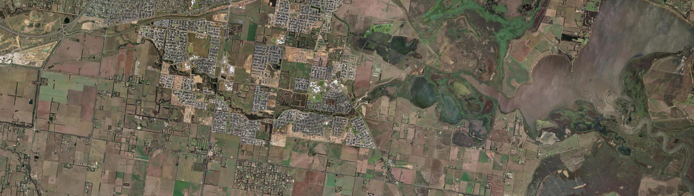
Aerial view of Armstrong Creek (Vic.), VIC

Aerial view

Imagery © Esri

The quick read on

Armstrong Creek

VIC 3217 · Greater Geelong

What homes cost, how rents have moved, and a feel for the people who call it home.

Median house
$682,000

latest suburb median

Population
11,247

ABS 2021

Postcode
3217

Armstrong Creek, Victoria

Property market insights for Armstrong Creek (Vic.)

Median sale price and rental income of properties in Armstrong Creek (Vic.) VIC

Median price trend for houses

Based on 531 sales in the preceding 12 months

$682,000

Up 4.9% over 12 months

$800k$600k$400k20212023202420252026
2 bed
$615k
3 bed
$640k
4 bed
$700k
5+ bed
$695k

Median rent trend for houses

Based on 738 rental listings in the preceding 12 months

$540 per week

Up 2.9% over 12 months

$600$550$500$45020212023202420252026

Market data updated October 2026.

The median house price in Armstrong Creek (Vic.), VIC is currently $682,000, based on the latest 12 months of sales. Armstrong Creek (Vic.) has a 12-month growth rate of 4.9% for houses.

Two-bedroom houses have a median sale price of $615,000, Three-bedroom houses have a median sale price of $640,000, Four-bedroom houses have a median sale price of $700,000, Larger houses have a median sale price of $695,000 in Armstrong Creek (Vic.).

If you're looking to lease, the median rent for houses in Armstrong Creek (Vic.) is $540 per week. The median house rent has increased 2.9% over the last 12 months.

Three-bedroom apartments and units have a median sale price of $570,000, Four-bedroom apartments and units have a median sale price of $622,000 in Armstrong Creek (Vic.).

Crime and safety

Is Armstrong Creek safe?

The overall rate for Armstrong Creek is 3,648 offences per 100,000 residents — 10% below the Rest of Vic. benchmark.

That is the clearest suburb-wide answer. Open the detailed profile to see how the pattern changes across offence types and different parts of Armstrong Creek.

Overall crime rate

3,648

offences per 100,000 residents

10% belowRest of Vic.

Armstrong CreekRest of Vic.: 4,070

Suburb-wide estimate from Microburbs' public crime model; it is not an address-level measure.

The people behind the postcode

Who lives in Armstrong Creek?

Armstrong Creek VIC 3217 is in Victoria, within Rest of Vic..

11,247 people call Armstrong Creek home, with an average of 2.9 people per household and a median household income of $2,200 a week.

Public ABS 2021 Census figures. The bars compare the local share with the capital-region benchmark.

Population
11,247
Median age
30 years
Median mortgage
$1,800 / month
2021 household rent
$420 / week
Above the benchmarkBelow the benchmarkIn lineRest of Vic. benchmark

Age profile

Share of residents in each age band.

Under 1525.9%Above
15–3435.9%Above
35–5425.8%Above
55–749.9%Below
75 and over2.6%Below

Homes

Share of occupied private dwellings.

Separate houses95.1%Above
Townhouses5.0%Below
Apartments0.0%Below

Ownership

Share of homes with a stated ownership or rental status.

Owned outright11.1%Below
Paying a mortgage54.0%Above
Renting34.9%Above

Cars at home

Vehicles available to occupied households.

No car1.2%Below
One car27.2%Below
Two cars53.5%Above
Three or more18.2%Below

Getting to work

Selected ways residents worked or travelled on Census day.

Worked from home18.1%Above
Drove to work62.7%Above
Train, tram or bus1.1%Above
Walked or cycled0.6%Below

What stands out in Armstrong Creek

18.1% of workers in Armstrong Creek worked from home on Census day.

3.9% of Armstrong Creek residents were born in India, about twice the rate across Rest of Vic..

52.0% of people in Armstrong Creek described themselves as having no religion in the 2021 Census.

A closer look at the Census

Questions people ask about Armstrong Creek

Open any question for a plain-English reading of the public 2021 Census for Armstrong Creek VIC 3217.

Is Armstrong Creek family-friendly?Age, family structure and household size describe the community families would be joining.

25.9% of Armstrong Creek's residents were children under 15 in the 2021 Census. That is well above the Rest of Vic. average.

3,033 family households lived in Armstrong Creek; 51.1% were couple families and 15.3% were one-parent families.

54.3% of local families included children under 15. That is well above the Rest of Vic. average.

These are suburb-wide household figures, not school or childcare ratings.

What is the age profile of Armstrong Creek?The balance between younger adults, families and older residents changes how a suburb feels day to day.

Armstrong Creek had 11,247 residents at the 2021 Census.

41.5% of residents were aged 25 to 44.

12.4% were 55 or older. That is about half the Rest of Vic. rate.

Age shares use the suburb’s total Census population.

What kind of homes are in Armstrong Creek?The dwelling mix shows whether the suburb is mostly detached homes, townhouses or apartments.

Separate houses made up 95.1% of occupied private dwellings in Armstrong Creek.

Townhouses and other attached homes represented 5.0% of occupied private dwellings.

Flats and apartments accounted for 0.0% of occupied private dwellings.

All three shares use occupied private dwellings as the denominator.

Do people own or rent in Armstrong Creek?Tenure shows how many households own outright, have a mortgage or rent.

11.1% of households with a stated tenure owned their home outright. That is about half the Rest of Vic. rate.

54.0% were buying their home with a mortgage.

34.9% rented their home. That is well above the Rest of Vic. average.

Tenure shares include households that stated one of these three arrangements.

How large are households in Armstrong Creek?Household-size data shows the mix behind the suburb-wide average.

The average household in Armstrong Creek had 2.9 people.

One-person households made up 13.5% of occupied homes. That is about half the Rest of Vic. rate.

Two-person households represented 31.2%, while 33.3% had four or more usual residents.

Household size counts usual residents in occupied homes.

How do people get to work in Armstrong Creek?Census-day travel shows the balance between home, road, public transport and active travel.

18.1% of workers worked from home on Census day. That is somewhat above the Rest of Vic. average.

62.7% drove a car as their only travel method. That is close to the Rest of Vic. average.

1.1% used only a train, tram or bus, while 0.6% walked or cycled.

Travel figures are a 2021 Census-day snapshot.

How many cars do households have in Armstrong Creek?Vehicle availability helps describe the routines local households can support.

1.2% of occupied households had no motor vehicle available. That is about half the Rest of Vic. rate.

One-car households formed 27.2% of the total.

71.7% of households had two or more vehicles.

Vehicle counts refer to occupied households, not individual residents.

Who's moving to Armstrong Creek, and who stays?Address history shows how settled or recently mobile residents were at the Census date.

22.4% were at the same address five years earlier, while 77.6% reported a different address.

18.9% of residents were born outside Australia. That is well above the Rest of Vic. average.

Mobility figures cover residents who answered the relevant Census question.

What languages are spoken in Armstrong Creek?Language at home gives a direct view of the community’s everyday linguistic mix.

83.4% of residents used only English at home.

13.6% used a language other than English at home.

0.8% spoke Mandarin at home, 0.1% spoke Cantonese and 0.6% spoke Hindi.

Home language is separate from English proficiency.

Where were Armstrong Creek residents born?Birthplace adds another layer to the local story, separate from ancestry and language.

18.9% of Armstrong Creek's population was born outside Australia, while roughly 81.1% was born in Australia.

0.5% of residents were born in China.

3.9% were born in India, while Australian citizenship across the whole suburb stood at 87.4%.

Birthplace, citizenship and ancestry describe different parts of identity.

What ancestries shape Armstrong Creek?Ancestry responses show how residents describe family and cultural background.

English ancestry accounted for 39.1% of ancestry responses in Armstrong Creek.

Australian ancestry made up 37.9% of responses.

Chinese ancestry represented 1.5% of responses.

People may nominate more than one ancestry, so these are shares of responses.

What work do people do in Armstrong Creek?Occupation describes a person’s role; industry describes the sector employing them.

23.3% of employed residents worked in professional occupations. That is somewhat above the Rest of Vic. average.

Managers accounted for 10.7% of employed residents, while clerical and administrative workers made up 11.6%.

Health care and social assistance employed 19.7% of workers, and education and training employed 9.9%.

Occupation and industry figures describe employed residents of the suburb.

How active is the workforce in Armstrong Creek?Participation, employment pattern and unemployment describe the resident labour force.

The labour-force participation rate was 79.0%, compared with 57.4% across Rest of Vic..

44.0% of residents aged 15 and over worked full time, while 27.2% worked part time.

Unemployment was 3.2%, compared with 4.1% across Rest of Vic..

Labour-force figures come from the 2021 Census.

What does the health profile of Armstrong Creek show?Selected long-term health conditions help describe community service needs.

64.8% reported no selected long-term health condition.

11.5% reported a long-term mental health condition, including depression or anxiety.

10.0% reported asthma, 4.6% arthritis and 2.9% diabetes excluding gestational diabetes.

These are self-reported suburb-wide Census figures, not address-level health risks.

How educated is Armstrong Creek?Qualifications describe the study pathways represented among local residents.

29.0% of people in the qualifications table held a bachelor degree. That is well above the Rest of Vic. average.

Postgraduate degrees accounted for 8.4% of qualification responses.

Diploma-level qualifications represented 18.4%, while certificate-level qualifications represented 33.2%.

Qualification categories are reported separately and are not school ratings.

What do incomes and housing costs look like in Armstrong Creek?Census income and household payments give historical context for local living costs.

Median household income was $2,200 per week in the 2021 Census.

The median monthly mortgage repayment reported by local households was $1,800.

Occupied renting households reported a median rent of $420 per week.

These household figures are from 2021; current sale and asking-rent medians appear in the market section.

How does Armstrong Creek compare with Rest of Vic.?A few clear differences place the suburb in its wider metropolitan context.

Working from home was 18.1% in Armstrong Creek, compared with 15.1% across Rest of Vic..

Outright ownership was 11.1% locally and 40.9% across Rest of Vic.. That is about half the Rest of Vic. rate.

Renting accounted for 34.9% in Armstrong Creek, against 24.5% across Rest of Vic..

Capital-region comparisons use the same Census definitions and year.

Three useful questions

A buyer’s quick guide to Armstrong Creek (Vic.)

Is Armstrong Creek (Vic.) expensive?

The median house price is $682,000. Bedroom count, land and condition still create a wide range around those suburb medians.

Is Armstrong Creek (Vic.) good for families?

The Census counted 3,033 local families, and 25.9% of residents were under 15. That describes the community; school quality, travel times and the right fit for a particular family need separate research.

What can I get for $1.5m in Armstrong Creek (Vic.)?

4-bedroom houses have a median around $700,000, the closest bedroom benchmark we hold to a $1.5m budget. Individual homes can differ substantially with block size, renovation and location.

Medians describe recorded market activity across the suburb; they are historical context, not a valuation or forecast for an individual home.

Explore the area

Streets and suburbs around Armstrong Creek (Vic.)

437 streets in Armstrong Creek (Vic.)

Street-by-street reports are not published yet. The streets below are the ones this suburb covers.

  • Aaron St
  • Aberfeldie Street
  • Abigail Ct
  • Abode St
  • Achelous Pl
  • Ackerman St
  • Ackland St
  • Aeolus St
  • Albanel St
  • Albatross Street
  • Alcyone St
  • Allansford Cr
  • Ambarella
  • Ambrosia Dr
  • Amiable Pde
  • Amphitrite Way
  • Anemone Walk
  • Anglet
Show all 437 streets
  • Angourie Pl
  • Ardea Street
  • Ashbury Bvd
  • Atherton St
  • Atlantis Way
  • Avalon
  • Avi Walk
  • Avocet
  • Avonbury Dr
  • Baenschs Ln
  • Barleycorn
  • Barracouta Dr
  • Barwarre Rd
  • Barwon Heads Rd
  • Batlow St
  • Batten Rd
  • Bayberry Street
  • Beard St
  • Beaurepaire St
  • Beekeeper Rd
  • Bega St
  • Belgravia Ln
  • Bentons
  • Berkeley Dr
  • Beveridge Circuit
  • Beverly
  • Bilimbi
  • Birdport
  • Bird Rock Road
  • Blackwattle Dr
  • Blissful Street
  • Bluewater Dr
  • Bolton St
  • Bondi St
  • Booker Pl
  • Boundary Road
  • Boyd Street
  • Brady St
  • Bridgewater Cct
  • Brindabella St
  • Broadford Crescent
  • Buchanan Bvd
  • Buckskin Avenue
  • Build St
  • Burgess Ave
  • Burnie St
  • Bursaria Street
  • Burvilles Road
  • Buttercup Crescent
  • Caitlin Ch
  • Calico Way
  • Canary Dr
  • Candide Gr
  • Canoe St
  • Cape
  • Cardamon St
  • Carisbrook St
  • Carswell St
  • Carter Rd
  • Caspian Crescent
  • Cassava St
  • Cavallo Road
  • Central Bvd
  • Ceriani St
  • Chamberlain Dr
  • Charlemont Rd
  • Chelsea Dr
  • Cherry St
  • Chesnet Street
  • Chesnut Street
  • Chestnut Street
  • Chucklecreek Ln
  • Cleary St
  • Cloudbreak St
  • Coastal Dr
  • Coastside Dr
  • Cocoon Pl
  • Conifer St
  • Consaw Street
  • Cootamundra Dr
  • Coquille
  • Corella Rd
  • Corvus Circuit
  • Countess St
  • Creekward Dr
  • Cremello Street
  • Cruise Pl
  • Crystall Pl
  • Currumbin St
  • Cuttlefish Street
  • Daisy Way
  • Dalmore Place
  • Dapple Avenue
  • Dapto Walk
  • Darter
  • Darwin Avenue
  • Davenport Street
  • Daybreak Ave
  • Decourcy
  • Deepwater Avenue
  • Deloraine St
  • Delphis Street
  • Delta Dr
  • Demeter Walk
  • Derby
  • Devenish Street
  • Devesha Drive
  • Dock Walk
  • Dooliebeal Ave
  • Doris Pl
  • Dorron Dr
  • Drift Ln
  • Duke St
  • Dunant Cct
  • Dunant Street
  • Dusty Crescent
  • Eaglebay Rd
  • Eaglehawk Ave
  • Eagle Rd
  • Edenhope Cct
  • Egret Drive
  • Egret Pl
  • Element Cct
  • Elmhurst Street
  • Elmshurst Street
  • Elouera St
  • Embling St
  • Esperance Ave
  • Esperence Avenue
  • Eucalypt Street
  • Eurybia Pl
  • Even
  • Evergreen St
  • Fairhaven St
  • Fairywren St
  • Falcon St
  • Fawkner Cr
  • Fistral St
  • Flagstaff St
  • Flanagan Cl
  • Fletcher Dr
  • Fleurieu Cct
  • Floral Way
  • Flow Way
  • Forbes St
  • Forresters
  • Freda Rd
  • Freshwater Dr
  • Furness Pl
  • Gahnia
  • Gahnia Drive
  • Galene Dr
  • Galley
  • Garfield Dr
  • Garganey Rd
  • Gellibrand Street
  • Gembrook Crescent
  • Gillieston Street
  • Glide
  • Glory
  • Goodenia Street
  • Grallina Way
  • Grassy Street
  • Greenmount Ave
  • Groves Rd
  • Guest St
  • Habitat
  • Half Moon Street
  • Hammond Street
  • Handfield Street
  • Harkaway Ln
  • Harkness Boulevard
  • Harriott Road
  • Harvey Ave
  • Haven Ct
  • Hedge St
  • Hermosa Ln
  • Hirst
  • Holbrook Dr
  • Holley Cr
  • Holst St
  • Homeland
  • Honey Suckle
  • Hooper St
  • Horizon Entrance
  • Horseshoe Bend Road
  • Hudson St
  • Hutton Cl
  • Impeller Ln
  • Inglenook Cct
  • Inverell Pl
  • Iris
  • Isle Ave
  • Jacana
  • Jetty Street
  • Jindabyne St
  • Kaisers Pl
  • Kangaroo
  • Keats Cct
  • Kempsey
  • Kidd Ave
  • Kingscliff Ave
  • Kite Walk
  • Kookaburra Dr
  • Koslow St
  • Krenz St
  • Kyogle Walk
  • Kyogle Way
  • Lagoon St
  • Lake Rd
  • Lampard St
  • Lance Dr
  • Langdon St
  • Languid St
  • Lapis St
  • Larus Drive
  • Lauderdale Court
  • Lester Avenue
  • Liberation Dr
  • Liffey Way
  • Lilywater Crescent
  • Lismore St
  • Lodge Pl
  • Longreach Rd
  • Lower Duneed Rd
  • Lusitano Street
  • Lyall St
  • Lyons Drive
  • Lyrebird Street
  • Macadamia Place
  • Macedon St
  • Mackerel Street
  • Maddern St
  • Madeira St
  • Main St
  • Mallacoota Cr
  • Mallard Walk
  • Mandalay Avenue
  • Mandalay Cct
  • Marentelli Avenue
  • Maroubra St
  • Martha St
  • Mcarthur Cr
  • Mccormack Ave
  • Mckinley Ave
  • Mcmahon Ave
  • Melaleuca Street
  • Mellori Way
  • Merrimack Pl
  • Metung St
  • Middleton Rd
  • Milla Ave
  • Mindil St
  • Mindl Street
  • Miramar Dr
  • Mistybrook Pl
  • Montagna Cct
  • Monterey St
  • Monteverde Street
  • Morningside Cct
  • Mudgee Place
  • Mulberry St
  • Myna
  • Nabiac Lane
  • Nairn Dr
  • Naismith St
  • Narrandera Cct
  • Naturaliste
  • Nature St
  • Nest Pl
  • Netherley
  • Neville Dr
  • Newland Drive
  • Newman Circuit
  • Newport Drive
  • Noosa Cct
  • Optimus Drive
  • Optimus Road
  • Orcan
  • Orchid Street
  • Paddock Rd
  • Paradise
  • Paradise Circuit
  • Peaceful Ave
  • Perlino Avenue
  • Petunia Crescent
  • Pier Street
  • Pintail Rd
  • Placid Pl
  • Ploughman Pl
  • Portrush
  • Prevelly Cct
  • Prominence Bvd
  • Purity
  • Pusilla Street
  • Rainford Pl
  • Raleigh Cct
  • Rarity St
  • Redgum Street
  • Reeve Ave
  • Restful
  • Ricky Pde
  • Rise Ave
  • Rivernook Street
  • Robinson St
  • Robwood St
  • Rochford Dr
  • Rockbank Walk
  • Rockingham St
  • Rocky Point Rd
  • Romley Ave
  • Ross St
  • Rottness Dr
  • Rutherford Gr
  • Sabino St
  • Sail Ct
  • Saltbreeze Bvd
  • Sampford St
  • Sanctuary Bvd
  • Sanderling Ave
  • Sandhill St
  • Sandspit
  • Sandvue St
  • Seaberry Street
  • Seachange Street
  • Seal St
  • Seashells Place
  • Secluded Dr
  • Seifferts St
  • Serene Ave
  • Serenity St
  • Settler Pl
  • Shearwater Dr
  • Shelter Pl
  • Shield Pl
  • Shipstern St
  • Silene Walk
  • Silky Oak Ln
  • Silvercrest
  • Simony Dr
  • Simpson Circuit
  • Singleton Cct
  • Sirrom Cr
  • Snedden St
  • Sobek St
  • Sola Place
  • Sonora Cct
  • Sophie
  • Sorell St
  • Southwinds Rd
  • Sparrovale Road
  • Spirit Cr
  • Spoonbill Dr
  • Stein Ave
  • Stephenson Dr
  • Stewarts Rd
  • Stingray St
  • Stump Jump Ln
  • Sugar Glider Street
  • Summerbreeze
  • Sundarban Crescent
  • Sundews Crescent
  • Sunrise Street
  • Sunshine Ave
  • Swaine St
  • Swansea
  • Swordfish Pl
  • Tamarillo St
  • Teags
  • Teatree Place
  • Teewah Walk
  • Tenneyson Cl
  • Tenterfield St
  • Tidepool Place
  • Tipene St
  • Tobiano St
  • Torquay Rd
  • Torse Ave
  • Tovero Avenue
  • Tranquility Cct
  • Tranquility Crescent
  • Trinity
  • Tritones
  • Trundle Dr
  • Tumino
  • Turret Pl
  • Twiggy Way
  • Tyntynder Cl
  • Ungud
  • Vale Cl
  • Vaughan Dr
  • Verona Gr
  • Verve Way
  • Vicosa
  • Vicosa Drive
  • Vienet Ave
  • Volant Dr
  • Walcott Pl
  • Wanda Walk
  • Wanders
  • Warralilly Boulevard
  • Warralily Bvd
  • Watt
  • Whalley Rd
  • Whelan Street
  • Whitecliff
  • Whitehaven Ch
  • Whitewater Crescent
  • Whitewing St
  • Whitfords Dr
  • Wild Oak Ave
  • Willow Walk
  • Windansea St
  • Winfield Ct
  • Winifred St
  • Woodside
  • Wynn Ave
  • Yellowbox Ave
  • Yellowfin Drive

Keep exploring

Is Armstrong Creek (Vic.) right for your search?

Use the finders to compare places and properties, or open the full report when you need the street, risk, schools and growth research.

Figures update as new market and census data arrives. This suburb overview is general information, not a valuation or financial advice.